User Tools
Sidebar
Action disabled: revisions
japan:tokyo_hiking:jinbasan-takaosan
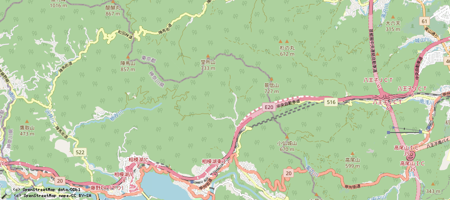
Jinbasan/陣馬山, Takaosan/高尾山 trip
operating instructions
Various functions are available as part of the map.
mouse/touch operation
- moving by grabbing the map with a mouse-click you can move the map around
- overview map using the < button in the bottom right of the map you can expand an overview map
- zooming in and out using the + and - buttons in the top left of the map you can obtain more or less detail in the map
- switching themes or maps clicking on the ≡ icon on the right-hand side of the map you can view and select available maps and themes
- retrieving information the map may contain elements that contain more information, by clicking these a popup will show this information
- fullscreen display using the ⛶ button the map can be maximized to fullscreen display, use the ▢ button to return to page display.
keyboard operation
Keyboard operation becomes available after activating the map using the tab key (the map will show a focus indicator ring).
- moving using the arrow keys you can move the map
- overview map using the + button in the bottom right of the map you can expand an overview map
- zooming in and out using the + and - buttons in the top left of the map or by using the + and - keys you can obtain more or less detail in the map
- switching themes or maps clicking on the ≡ icon on the right-hand side of the map you can view and select available maps and themes
- retrieving information the map may contain elements that contain more information, using the i key you can activate a cursor that may be moved using the arrow keys, pressing the enter will execute an information retrieval. press the i or the escape key to return to navigation mode
- fullscreen display using the ⛶ button the map can be maximized to fullscreen display, use the ▢ button to return to page display.
It's possible that some of the functions or buttons describe above have been disabled by the page author or the administrator

| id | symbol | latitude | longitude | description |
|---|---|---|---|---|
| Trail Fujino/藤野, Jinbasan/陣馬山, Takaosan/高尾山, Takaosanguchi/高尾山口 | ||||
 |
 |
GPX track: track2019-05-25 陣馬山 高尾山 | ||
Trip details
- take train to 藤野駅/Fujino Station (~90min from Shinjuku)
- then walk to 陣馬登山口/Jinbatousanguchi (~25min)
- then walk to 陣馬山/Jinbasan. There are plates for the path, 2 different ways can be used, details are here: https://ridgelineimages.com/hiking/mt-jinba/ . Walking upwards via the west side way takes 90-100min. At the top, the white horse can be seen, also food is sold. View to Mount Fuji on good days. Android app 'osmond' uses openstreetmap data and also knows the way.
- From there, one can go back to 陣馬登山口/Jinbatousanguchi, or do the following:
- walk to 景信山/かげのぶさん/Kagenobusan (~120min, https://retrip.jp/articles/12934/). The way is ontop of a mountain pass in the woods, very nice.
- walk to 小仏城山/こぼとけしろやま/Kobotokeshirosama (~45min)
- walk to 高尾山/たかおさん/Takaosan (~50min)
- walk to 高尾山口駅/たかおさんぐちえき/Takaosanguchi station (~60min), there is a bath in the train station, then back to Tokyo
- trip history:
- 20191116, 20200102, 20200211
- 20200724: This was in the last days of the rain season, the ways had turned into pure mud. Some places were slippery. 27°C air temperature, light dripping rain is just right and refreshing. All stores were open: 2 at Jinbasan, one at Kagenobusan, 2 at Kobotoke, and some at Takaosan.
- 20201002: For the first time, trip from Takaosanguchi to Jinbasan. T-shirt and short trousers were still sufficient.
japan/tokyo_hiking/jinbasan-takaosan.txt · Last modified: 2024/04/06 06:47 by chris
Page Tools
Except where otherwise noted, content on this wiki is licensed under the following license: CC Attribution-Share Alike 4.0 International

